ACTION NEEDED: North & South Moreland

The City of Cleveland is seeking public feedback as they prepare plans to repave North and South Moreland Boulevards. You can learn more on the project website: NorthandSouthMoreland.com.
The current plan being proposed is:
- Repair and resurface the roadway.
- Reconfigure Intersections (including bump-outs and realigning intersections to reduce pedestrian crossing distances) at:
- Livingston Road
- Ashwood Road
- Hampton Road
- Buckeye Road/S. Woodland Road
- Drexmore Road
- Replace curbs, driveway aprons, sidewalks and curb ramps as needed.
- Add ADA compliant curb ramps where they currently do not exist.
- Reconstruct catch basins and reset utility castings.
- Replace 7,000 feet of water main and install new connections, valves, and hydrants.
- Install new high visibility pavement markings and signage, including bike lanes along South Moreland Boulevard and sharrows along North Moreland Boulevard. Parking lanes will remain along the entire corridor.
- Replace signals at Buckeye Road/S. Woodland Road and Drexmore Road intersections and remove the unwarranted signal at Ashwood Road.
- Relocate and consolidate poles when possible (utility pole owners).
BIKE CLEVELAND RESPONSE
We are pleased to see bump-outs and realigned intersections to improve pedestrian safety, as well as bike lanes on South Moreland. These are commonplace improvements to overall road safety in the City’s commitment to Vision Zero.
There are two areas of deep concern:
- The designed dedicated left turn lane at Drexmore that cuts through the existing median. This drastic change to the look and feel of the neighborhood as a solution to reducing the traffic light cycle time for automobiles does not appear to improve or make this intersection safer. In addition, this would result in the loss of at least 5 mature trees.
- The North Moreland section of the project (Shaker Square to Larchmere). The City intends to break the potential connectivity to Larchmere and the Lake-to-Lakes Trail by using shared lanes (sharrows) in place of dedicated bicycle infrastructure (bicycle lanes or protected bicycle lanes). With the same street width as South Moreland to work with, and only mildly higher traffic counts – we see no reason for the emerging bicycle network to be disrupted here.With the ample roadway width involved, there is also the potential for the City to advance non-vehicle mobility by installing separated facilities within the roadway, by potentially using parking protected lanes – or even separated lanes (both depicted below) along the center median. These would be new types of facilities for our area, but they have been utilized in other cities that are increasing the safety and comfort of vulnerable road users.
- The plans presented on the project website (https://www.northandsouthmoreland.com/) do not address the striping plan around Shaker Square and how accomodations will be improved for the most vulnerable road users navigating the Square.
-

- Kansas City – PPBL

-
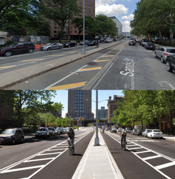
- Sands Street – Brooklyn, NY
SUBMIT PUBLIC FEEDBACK
Please help us work towards a more complete bicycle network by providing your public comment here: NorthandSouthMoreland.com/copy-of-public-feedback .
There is also a public meeting for the project taking place where residents can share concerns and feedback:
When: Tuesday, September 20th @ 6pm
Where: Atlas Cinemas at Shaker Square (13116 Shaker Square, Cleveland, OH 44120)
Meeting Flyer: Download here.
